WE ARE MANY.
WE ARE RAILFANS.
Railfan-Joe
October 15th, 2020
Britain, given its small landmass, hosts an incredibly compact network of railways from the very top of Scotland, right through to the Cornish peninsula, but what is perhaps more staggering, is that over time, thousands of miles of rail network have been lost through cuts and changes in the industrial landscape, meaning that what remains is just a fraction of what once existed throughout the nation.
Finding signs of these lost railways isn’t always easy. After all, track beds have been paved over, stations demolished and yards built on. But one vital tool in finding relics of bygone lines are readily available Ordnance Survey Maps, which can depict local landscapes in incredible detail.
Below, we outline a number of examples where these maps can highlight a railway past, but we’d love you to get involved and show us what history lies on your doorstep. Share your finds with us via Facebook, Twitter or Instagram, but please remember to stick to publicly accessible land or get permission from land owners before exploring private land. Some lines with track still in place may seem abandoned but, unless otherwise stated, should be treated as 'live' and therefore not safe to walk along.
Photos by Joe Rogers, unless otherwise stated.
For the most part, lost lines are marked on Ordnance Survey maps with the phrase ‘dismantled railway’ or similar and the path of the P-way can be traced by following what is left of the embankments and cuttings.
 In this example (above), at Newtyle in Scotland, the notation ‘dismtd rly’ denotes the loss of an entire junction, with traces branching off in numerous directions. Newtyle was the terminus of the first commercial railway in Scotland. © Crown copyright 2020 Ordnance Survey. Media 080/20
As well as the actual railway itself, associated pieces of infrastructure would have been torn down as lines became unwanted or redundant. In Gloucestershire, along the banks of the River Severn, the map shows two arms of an old railway line seemingly ending up in the river itself. In fact, this marks the location of the Old Severn Railway Bridge which was demolished in 1965 following a tragic accident five years earlier.
 Bridge piers (below - taken from the eastern bank) can still be seen today by walking along the nearby public footpaths – marked green on the map (above). © Crown copyright 2020 Ordnance Survey. Media 080/20.

Where stations have remained in towns and villages once connected to the rail network, often they have become private homes and finding them can at times be a challenge. By following the features of the map, often explorers can stumble across former stations, like that in Combpyne, in East Devon.
 The Cannington Viaduct (above) remains and can be picked out from the map crossing Cannington Lane (below). The station, now a house, has been highlighted by the superimposed circle. © Crown copyright 2020 Ordnance Survey. Media 080/20.

In the Somerset village of Axbridge, the former station is now a meeting place for the local Sea Cadets, but what is interesting here, is that the railway line, which linked Yatton with the cathedral city of Wells, has been replaced in part by the A371 road to Cheddar. The location of the Station is at the centre of the circle (above - superimposed) north of the church. Motorists briefly follow the course of the Ceddar Valley line, past the station (below). Elsewhere, a significant part of this line has been designated a cycle path, including the Shute Shelve Tunnel. © Crown copyright 2020 Ordnance Survey. Media 080/20

But these lost relics are not just found across rural Britain. In the cities, branches to large bygone industries and rail depots have made way for housing, recreation and commercial offices, with only the infrastructure needed for modern day commuters and travellers remaining amongst the urban sprawl.
 At Aldersley, Wolverhampton, the path of the South Staffordshire line to Pensnett can be seen on maps as it branches off from the mainline that remains. In this photo (below), taken approx from the location of the arrow (above - superimposed), 'Hinderton Hall' can be seen hauling freight c.1962 before the line was removed. © Crown copyright 2020 Ordnance Survey. Media 080/20
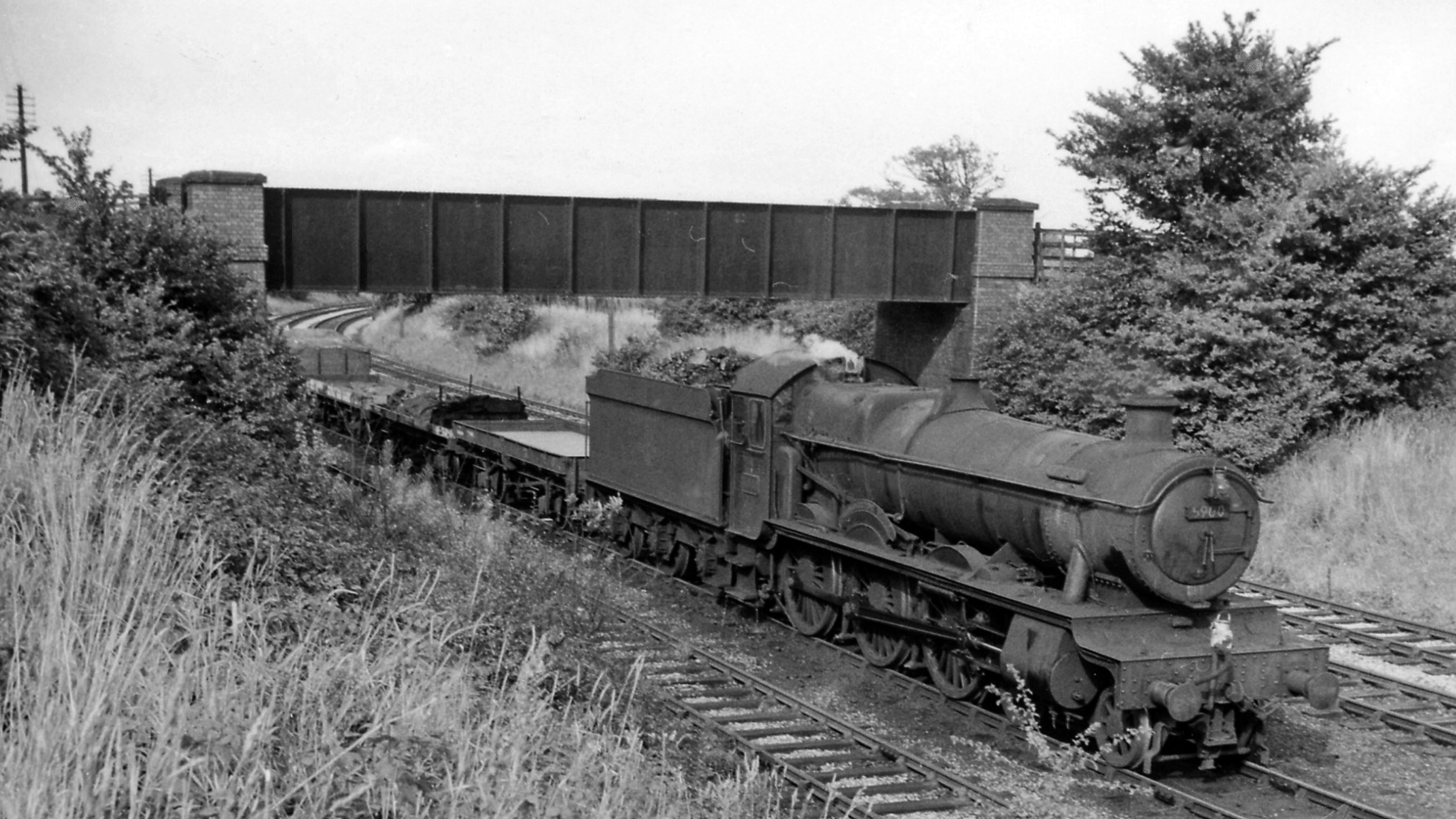 Photo by Ben Brooksbank CC-BY-SA 2.0
In the capital, any land taken up by former railway lines is quickly swallowed up through development. Often, few signs exist at ground level, but OS Maps can sometimes throw up hints of what was once in place.
 Here, in the heart of London, traces of a former route into the demolished Broad Street Station can be seen with a rare patch of white space denoting the position of the tracks (above - superimposed). The arrow points to Holywell Street (below) where the remains of a viaduct are seen, incorrectly adorned with former London Underground stock, which never ran publicly on this line. © Crown copyright 2020 Ordnance Survey. Media 080/20
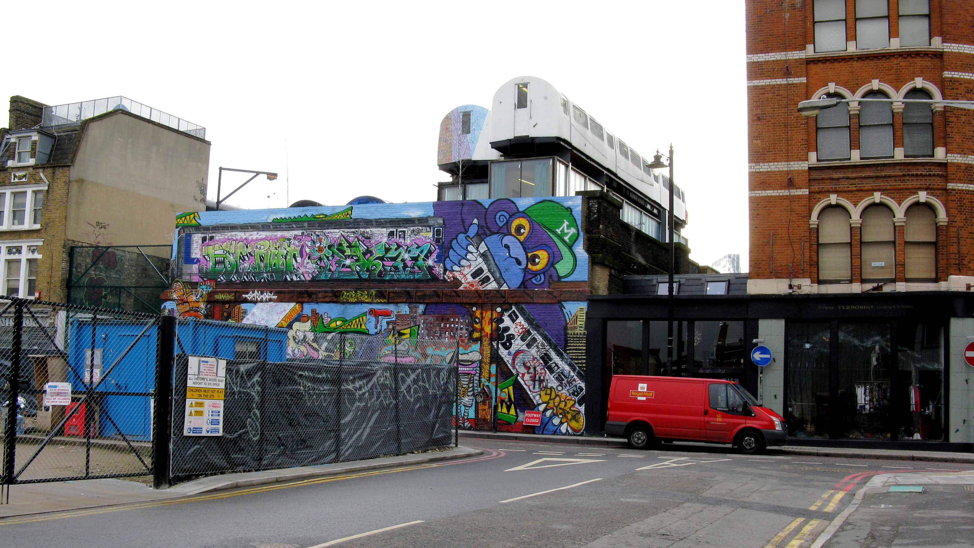 Photo by Dr Neil Clifton CC-BY-SA 2.0
The availability of these maps in both digital and paper formats means that anyone wishing to explore their local railway past in the UK can do so easily by looking out for the traces of embankments, old stations and sidings before heading out across the network of public footpaths and cycleways in search of lost railways.
Photo by Dr Neil Clifton CC-BY-SA 2.0
The availability of these maps in both digital and paper formats means that anyone wishing to explore their local railway past in the UK can do so easily by looking out for the traces of embankments, old stations and sidings before heading out across the network of public footpaths and cycleways in search of lost railways.